Physical Planning & Environmental Consultants
Planning Sustainable Places. Shaping Better Communities Across Kenya.
Peville Planners Limited delivers innovative, participatory and evidence-based planning, surveying, GIS and environmental solutions. We help governments, institutions, developers and communities make informed decisions that support sustainable growth across Kenya.
Evidence-Based
Participatory
Sustainable Impact
Nationwide Reach
Trusted planning capacity for public, private and community projects

Integrated Expertise
Planning, GIS, surveying and environmental solutions
Planning for
Posterity
About Peville Planners
Integrated Planning for People, Places and Posterity
Peville Planners Limited is a physical planning and environmental consultancy delivering practical, evidence-based solutions for sustainable development across Kenya.
Our multidisciplinary approach brings together planning, surveying, GIS, environmental management, research and policy expertise. We work with government agencies, institutions, developers, organizations and communities to turn complex development needs into clear, workable plans.
“We combine local knowledge, reliable data and professional insight to create plans that work today and serve future generations.
Founder’s Vision
“We plan with purpose, evidence and posterity in mind.
Great places begin with listening, data, and collaboration.
Peter Kaberere
Founder & Lead Planner

Physical Planning, GIS & Environmental Services in Kenya
Need Clarity Before You Develop? Our Planners Can Help!
Successful development starts long before construction begins. It starts with accurate information, a clear plan and the right technical guidance.
Peville Planners Limited helps landowners, developers, county governments, institutions and development partners move from uncertainty to informed action.
Based in Nairobi and serving clients across Kenya, we provide physical planning, surveying, GIS, environmental and development advisory services tailored to each site, project and community.
✓
```
Clear technical guidance for land, development and public-sector projects in Nairobi and across Kenya.
```
01
Physical and Land Use Planning
Make better use of land with a plan that is practical, compliant and ready to guide development.
Our physical planners in Nairobi support residential, commercial, institutional and public-sector projects across Kenya. We prepare land-use plans, development frameworks and planning proposals that help clients organize space, coordinate infrastructure and reduce costly development mistakes.
Explore This Service →
02
Environmental Management and Climate Change
Is your project prepared for environmental risks, approval requirements and changing climate conditions?
We help clients integrate environmental responsibility into planning and development. Our services include environmental studies, climate-responsive planning, sustainability strategies and natural-resource management for projects in Nairobi and throughout Kenya.
Explore This Service →
03
Topographical Mapping and Cadastral Survey
Do not make major development decisions using incomplete site information.
Our topographical mapping and cadastral survey services provide reliable details about boundaries, terrain, existing features and site conditions. This gives developers, institutions and landowners the clarity they need before planning, subdividing, designing or building.
Explore This Service →
04
GIS, Remote Sensing and Land Information Systems
Turn complex location data into information you can use.
Our GIS services in Nairobi and across Kenya support land-use analysis, infrastructure planning, environmental monitoring, development control and asset management. We create clear maps, spatial databases and visual insights that make technical information easier to understand and act on.
Explore This Service →
05
Policy Formulation and Development Advisory
Strong policies should do more than look good on paper. They should guide real decisions and respond to local needs.
We support county governments, institutions, NGOs and development partners with policy research, stakeholder engagement, strategic planning and development advisory services. The result is a practical framework that people can understand, implement and measure.
Explore This Service →
06
Monitoring, Evaluation and Research
Are your plans, programs and development projects producing the intended results?
Our monitoring, evaluation and research services help clients track progress, identify gaps and improve performance. We develop indicators, collect and analyse information, engage stakeholders and turn findings into useful recommendations for future action.
Explore This Service →
How We Work
From First Conversation to a Plan You Can Act On
Complex land and development decisions become easier when the process is clear.
Whether your project is in Nairobi or elsewhere in Kenya, Peville Planners Limited follows a structured, collaborative approach built around reliable information, stakeholder input and practical outcomes.
✓
Clear communication and practical guidance at every stage of your planning assignment.
01
Understand the Assignment
Discover and Define
We begin by understanding your land, project, goals and concerns. This first conversation helps us define the scope, identify the right technical services and establish a clear direction before work begins.
02
Build the Evidence Base
Research, Survey and Analyse
Our planners and technical professionals gather the information needed to support sound decisions. Depending on the assignment, this may include site assessment, surveying, GIS analysis, environmental review, research and stakeholder engagement.
03
Shape the Best Solution
Plan, Design and Validate
We turn the findings into practical planning options, maps, strategies or development frameworks. Clients and stakeholders remain involved so that the final recommendations reflect real needs, technical requirements and future growth.
04
Move From Plan to Action
Deliver and Support Implementation
You receive clear, professional outputs that can guide approvals, investment, development or policy action. We also provide clarification, presentations and technical support to help you move confidently into implementation.
Selected Projects Across Kenya
See How Better Planning Turns Complex Sites Into Clear Direction
Every site, policy and development challenge is different. Our role is to bring together reliable information, professional judgement and practical planning solutions that help clients move forward with confidence.
Explore selected physical planning and environmental assignments undertaken in Nairobi, Malindi, Kiambu and other parts of Kenya.
View All Projects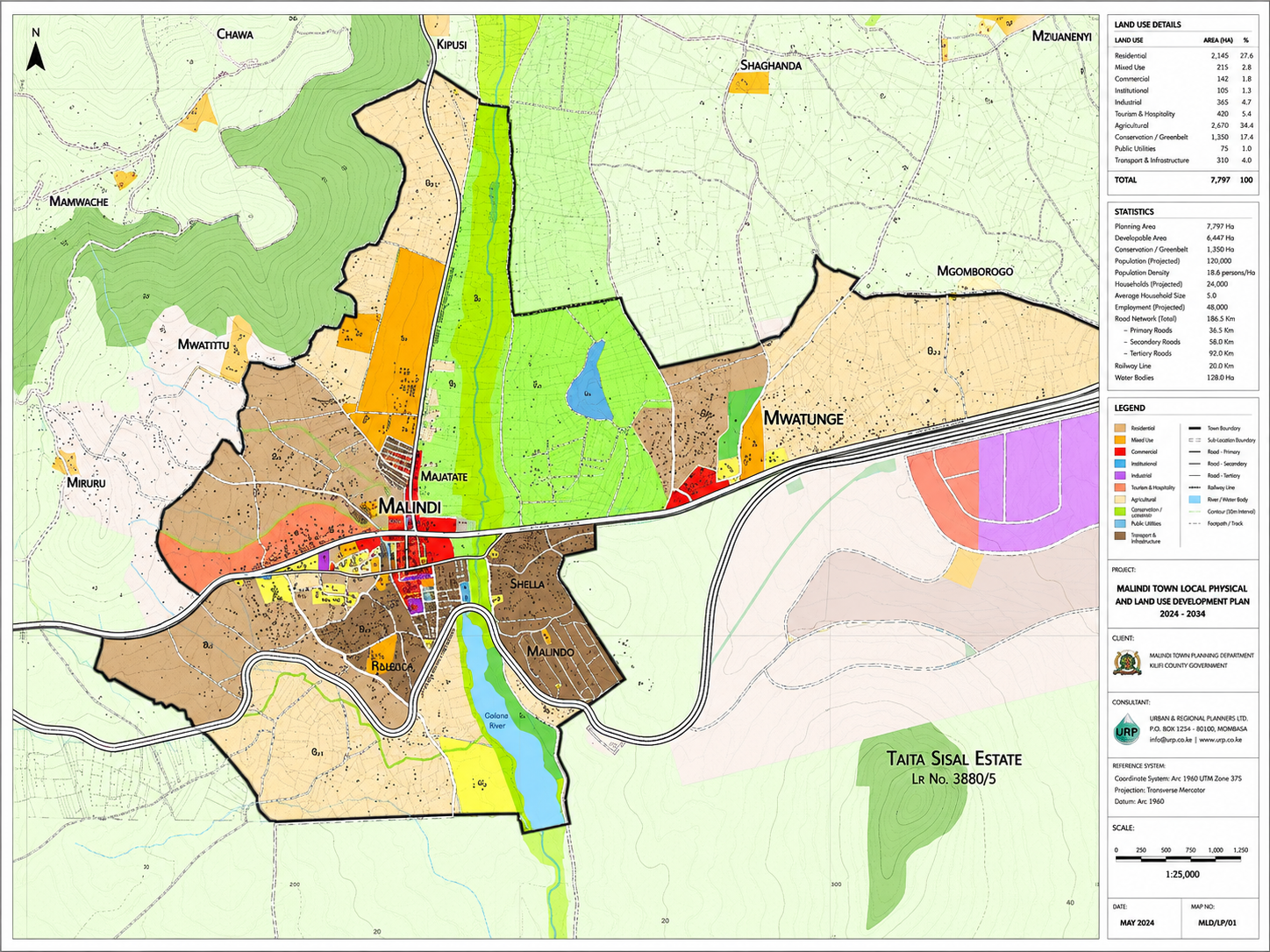
Magarini, Malindi
Land-Use Planning
Featured Assignment
Comprehensive Land Use Plan
A comprehensive planning assignment for a development site in Malindi Phase 2. The scope included subdivision and change-of-use planning to establish a clear framework for organized and sustainable development.
Explore This Project
→
Baba Ndogo, Nairobi
Environmental Management
Environmental Assessment for a Manufacturing Plant
An environmental impact assessment examining the project setting, potential impacts and considerations needed to support responsible industrial development.
View Project
→
Kamakis, Kiambu
Environmental & Social Assessment
Environmental and Social Assessment for an Office Development
An assessment supporting informed planning by identifying environmental and social matters requiring consideration before development.
View Project
→
Multidisciplinary Delivery
One assignment. Connected technical insight.
Physical Planning
GIS & Mapping
Surveying
Environmental Advisory
Start a Similar Project
→
Frequently Asked Questions
Planning a Project in Kenya? Start With Clear Answers.
Find helpful answers about physical planning, GIS, surveying, environmental assessments, project approvals and working with Peville Planners Limited.
Physical Planning
GIS & Mapping
Environmental Advisory
```
```
```
01 What services does Peville Planners offer?
Peville Planners Limited provides physical and land-use planning, environmental management, topographical mapping, cadastral survey support, GIS, remote sensing, policy advisory, monitoring, evaluation and research. These connected services help clients make informed decisions about land, infrastructure and development projects.
02 Which areas in Kenya do you operate in?
We are based in Nairobi and provide physical planning, GIS, surveying and environmental services across Kenya. Our assignments cover urban, peri-urban and rural areas. Before work begins, we review the location, technical requirements, available information and authorities involved.
03 How do you ensure community involvement?
Community participation may include stakeholder mapping, consultative meetings, interviews, workshops, local leadership engagement and public feedback sessions. We document relevant concerns and use the findings to identify priorities and create practical planning solutions.
04 How do I get started with Peville Planners?
Share your project location, intended development, available ownership or site documents, current challenges and preferred timeline. We will review the information, arrange an initial consultation and recommend the right planning, surveying, GIS or environmental services.
05 Do you handle approvals and regulatory submissions?
We help clients understand planning requirements, prepare technical plans and reports, coordinate supporting documents and respond to review comments within the agreed assignment. Final approval decisions and processing times remain under the relevant county or national authorities.
06 Do you conduct Environmental Impact Assessments?
We support environmental and social assessments according to the project type and applicable requirements. The work may include baseline review, site assessment, stakeholder consultation, impact identification, mitigation planning and preparation of environmental documentation.